
Taking advantage of our four day weekend here during Chinese New Year, Michael and I went on a little hiking adventure to Lion Rock in Kowloon this weekend.
This was the first time in our entire time in Hong Kong, barring the very first Chinese New Year holiday that I celebrated here weeks after I arrived, that I have not gone away. As I may have mentioned in a previous post, I was really, really eager to go away on a last minute trip. And up until a week ago, I was still holding fast to the idea of a last-minute whirlwind trip to Nepal. There were still tickets available to Kathmandu!! January has no crowds and the visibility is crisp and clear!! (Never mind that it is very, very cold in Nepal currently...and that was likely why no one wanted to spend their lunar new year holidays shivering in a tent in sub-zero temperatures.) However, for a variety of reasons, we ultimately decided that it was best that we took it easy this holiday and stay in Hong Kong. And as much as it saddens me to say it, I think it was the right choice.
So, we found ourselves headed to do the Lion Rock hike for the first time. It's frankly embarrassing that we haven't tried this hike before! It is very accessible. Below, step by step instructions to the trail head and also some pictures from our hike. I was "boots" and he was "socks" - not very creative but, you guessed it, I was wearing my very legitimate pink hiking boots, and he was wearing his hiking socks pulled up way up high (a sexier look ne'er have I seen).
First, we took the MTR to the Wong Tai Shin stop on the green line, then got out at exit B3. Once we emerged from the MTR, we turned right - we walked under this archway and then up a few flights of stairs
 where we found ourselves in this big plaza (though currently a lot of it is under construction, and my picture might be misleading because we saw a lot of new year festivities happening at the Wong Tai Shin temple on the day we visited):

That's a lot of people!
 From there, we walked straight, continuing through the big square until we came to the end, where there is a frenetic minibus depot. The hills way yonder in the picture below are where we're headed.
 We began to walk up Shatin Park Road - all the way up, up, up. You've been warned - it is a relatively arduous hike up to the trail head! There were many points as we huffed and puffed up the hill that we were convinced we were walking the wrong way. However, just keep taking Shatin Pass Road. After about 15 minutes (but which, with the sun coming out and the air getting muggier, felt more like 30), we got to the top of the hill and saw this peaceful little temple on our left.
 A little bit after that point, we made a right and continued up the road. At this point, it starts to feel much more like a pedestrian path, although cars can still drive up. My friend told me that when she did this hike, they drove all the way up, which means they drove well past this point. I felt both indignant and envious - if you do this, you
 are cheating will have a much easier and quicker trek!
 You will hike past a random water reservoir.
 There are a lot of random electric towers strung along this hike - more of them to be featured soon.

 We began to see sweeping views of Kowloon to our right (including lots of big, blocky, unwieldy public housing complexes) as we continued to ascend.
 We finally reached the point where the cars had to stop. However, note that you do not (I repeat, do NOT) want to go up this red archway).
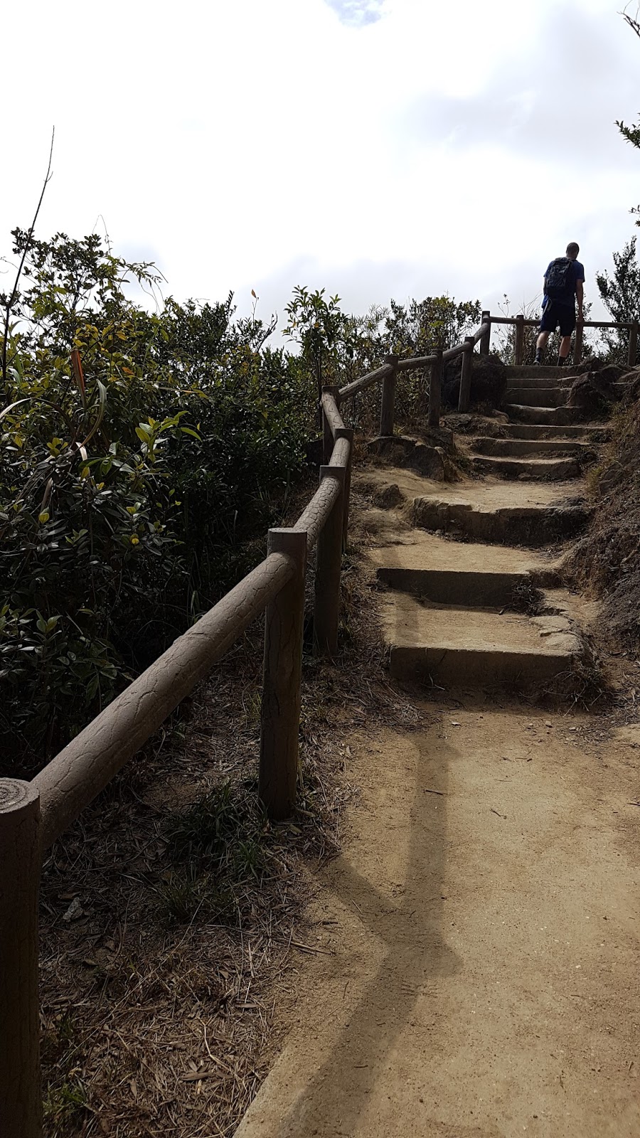
 Instead, you want to walk a bit farther until you see a brown sign stating in English and Chinese, Lion Rock Country Park. This is, finaaaaally, the start of the trail head. By this point, if you're like me, you'll already be pretty sweaty (having completely overestimated how cold it will be) and feeling a bit tired...
 Most likely you will see a lot of people sitting here snacking and resting. But once you clamber up the steps a bit, you will finally be on the trail! The hike is only 1.8 km long from this point before you hit the signpost for Lion Rock, so it is not too bad.
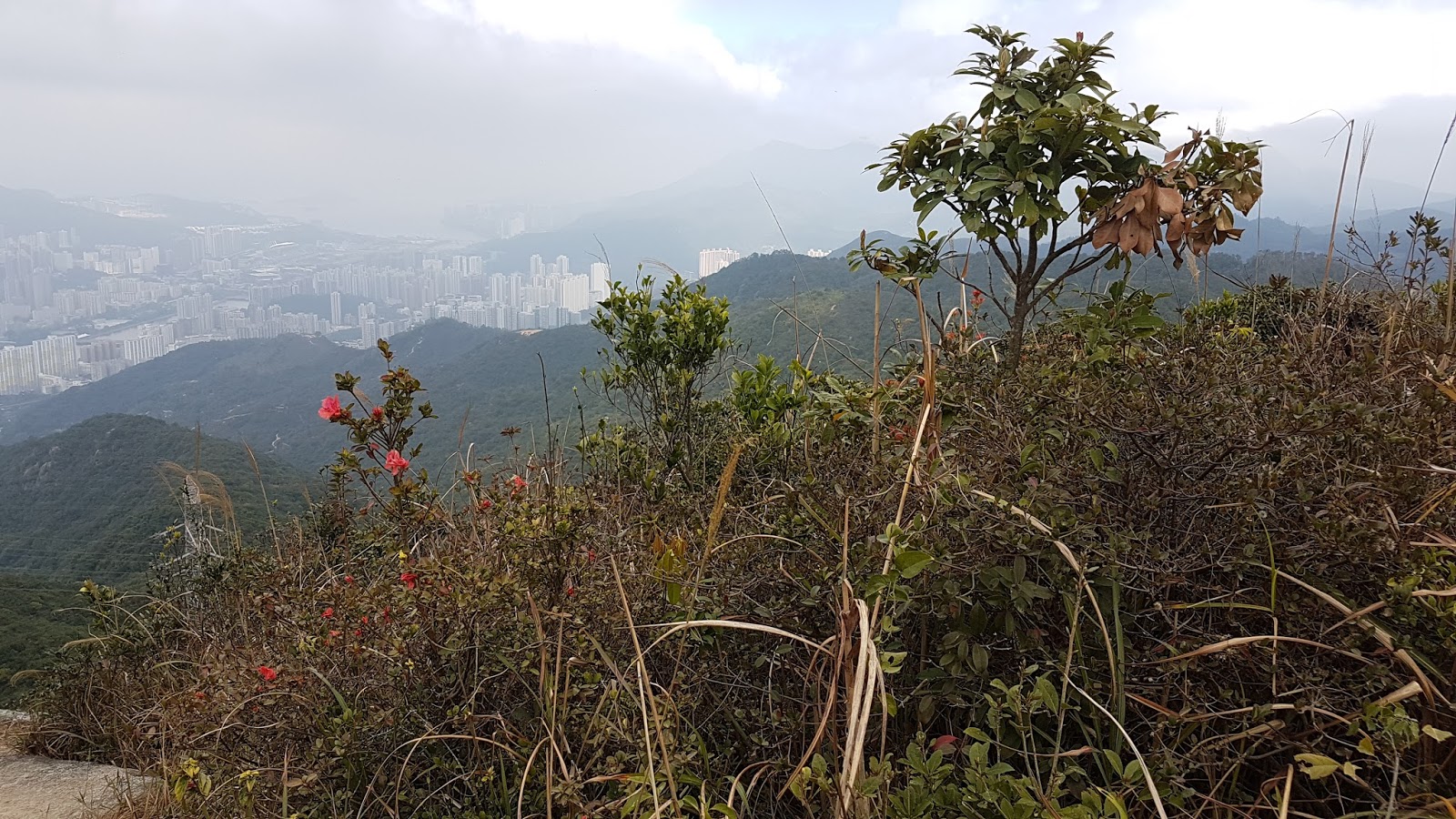
 There will be quick glimpses of Kowloon and the harbor along the way as you slowly wind your way up the mountain. Unfortunately, we went on a pretty overcast and slightly polluted day, so the haze obstructed our view.
 For some sections, we were the only ones on the trail and it was blissfully serene.
 Climbing steadily and steadily higher...


 It's mostly green foliage, but there are some dashes of red here and there.


 This is a picture of me near the top, pausing to catch my breath! It looks like this the whole way.
 When you arrive though, lungs and legs burning, it will be clear because there are lots more signs to greet you!

 There is a sign that tells you NOT to go this way - so of course lots of hikers duck under the wood posts and continue on their merry way.
 From here, the view is pretty spectacular, even on a non-clear day.

 Selfie pic at the top! I had whipped out my sweat towel at this point.
 Some more obligatory hazy pics.


 There were a bunch of mountain climbers/rappellers doing something kind of crazy looking.
 I was pretty happy where I was and decided not to fight the crowds of people to get to the other part of the summit. Some of the areas looked really narrow and the boisterous crowds did not seem the most considerate of the space. I didn't want to jostle with others. In case it is not clear in my pictures, basically the two peaks are connected
by a short path that dips down and then comes back up.
I was pretty happy where I was and decided not to fight the crowds of people to get to the other part of the summit. Some of the areas looked really narrow and the boisterous crowds did not seem the most considerate of the space. I didn't want to jostle with others. In case it is not clear in my pictures, basically the two peaks are connected
by a short path that dips down and then comes back up.
 Michael did go to the other side though, and I got a picture of him standing at the top with his arms raised high.
 After a quick snack, we were ready to head back down. After the crowds of people at the top, descending was a relief.
 We took a shortcut route about a quarter of the way down, taking a right and heading down via the Sha Tin Pass Estate route instead. This was a very well paved path (some parts were laid like patio stones) and didn't so much feel like a trail. There aren't any views this way, but there are less people and I always figure the descent should just happen as quickly as possible.
 This path brought us out to a point just past the reservoir (pictured above). I would suggest hiking the way we did when going up, and then coming down this way. When we emerged, we were able to give a very sweet mainland Chinese family some instructions (Michael even running back to give them clarifications in Mandarin), and then we saw this family plucking tender bamboo shoots! I love seeing foraging happen - this is proof that there are edible things all around us. Yes!
 Yep, foraging can happen within a couple of hundred feet of this!
 When we finally got back down to the Wong Tai Shin MTR stop (same way we went), my trusty nose led me right to this old-school cart. They were selling roasted sweet potatoes, chestnuts and quail eggs. I bought a big, juicy, sweet sweet potato. I love the way these sweet potatoes are cooked to caramelized perfection.

This was the first time in our entire time in Hong Kong, barring the very first Chinese New Year holiday that I celebrated here weeks after I arrived, that I have not gone away. As I may have mentioned in a previous post, I was really, really eager to go away on a last minute trip. And up until a week ago, I was still holding fast to the idea of a last-minute whirlwind trip to Nepal. There were still tickets available to Kathmandu!! January has no crowds and the visibility is crisp and clear!! (Never mind that it is very, very cold in Nepal currently...and that was likely why no one wanted to spend their lunar new year holidays shivering in a tent in sub-zero temperatures.) However, for a variety of reasons, we ultimately decided that it was best that we took it easy this holiday and stay in Hong Kong. And as much as it saddens me to say it, I think it was the right choice.
So, we found ourselves headed to do the Lion Rock hike for the first time. It's frankly embarrassing that we haven't tried this hike before! It is very accessible. Below, step by step instructions to the trail head and also some pictures from our hike. I was "boots" and he was "socks" - not very creative but, you guessed it, I was wearing my very legitimate pink hiking boots, and he was wearing his hiking socks pulled up way up high (a sexier look ne'er have I seen).
First, we took the MTR to the Wong Tai Shin stop on the green line, then got out at exit B3. Once we emerged from the MTR, we turned right - we walked under this archway and then up a few flights of stairs


That's a lot of people!
 We began to walk up Shatin Park Road - all the way up, up, up. You've been warned - it is a relatively arduous hike up to the trail head! There were many points as we huffed and puffed up the hill that we were convinced we were walking the wrong way. However, just keep taking Shatin Pass Road. After about 15 minutes (but which, with the sun coming out and the air getting muggier, felt more like 30), we got to the top of the hill and saw this peaceful little temple on our left.


I like looking back and seeing the clouds rolling in. Seeing the people behind us on the trail, traversing the path from which we just came, is also fun.


When you climb high enough, you start to get views on both sides - to the right, are views of Kowloon and the New Territories.
We thought we passed it when we did the hike, but it turns out the trail is very clearly marked and you really can't miss it. About 20 minutes (at our pace) or about 30 minutes pace (at a normal pace when Michael isn't your hiking companion), you will see a little sign that indicates a turn off for Lion Rock Peak. You want to take this. Another hint? If you're tired, you may want to rest here for a little bit. This part is, no joke, a straight, sheer, vertical, upward trajectory.
As part of this portion, you will come upon a large electric tower built directly over the path. Walk under it and try not to cringe as you hear all the buzzing from the electricity! Photo credit to Michael for this one, shot while standing directly underneath it.


 Michael did go to the other side though, and I got a picture of him standing at the top with his arms raised high.


